Mount Kita 北岳
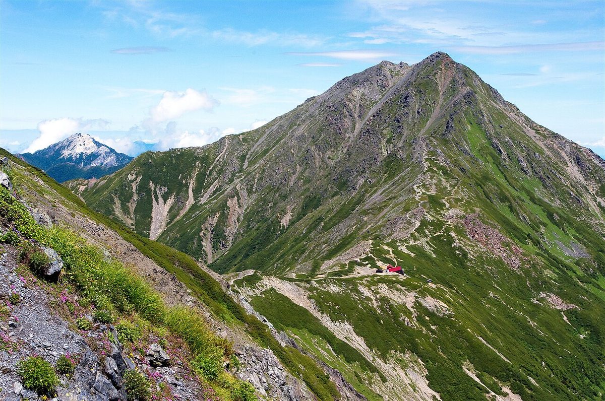

| Elevation | 3,193 m (10,476 ft) |
|---|---|
| Prominence | 2,239 m (7,346 ft) |
| Location | Yamanashi, Japan |
| Region | Chubu |
| Famous Mountains list | No. 80 of the 100 Famous Japanese Mountains (Nihon Hyaku-meizan) |
| Coordinates | 35.67432° N, 138.23874° E |
Next to Mount Fuji is the second highest peak in Japan, and the highest mountain not a volcano in Japan. This mountain is the main source of the river, from the upper part of the river. It's made up of sedimentary rocks of all the ancient mountain layers.
Geography
It's located in the north of the Red Stone Mountains and is the northern edge of the White Plateau system. The red stone system, the major mountain system of the mountain range, is separated by the Nose River. On the east side of the ridge is a ridge hanging from Ike Mountain and on the north side is a ridge with Otaro Mountain. The Red Stone Mountains tend to be of the 40,000 layers made up of sedimentary sedimentary rock in the middle of the civilization, and our mountain formations belong to the 40,000. The summit shows a steep mountain surface, but this is because it is a mixture of rock formations, such as limestone and pictograms and ocean basalt. These rocks are hard to eat, but they build sharp peaks not to be seen very often in the Red Stone Mountains. The zXQ 126X Batrees that follow are also made up of limestone and charts, and they are made up of rocks that are different from the surrounding ones in redstone mountains with the loose ridges. On the other hand, the Little Tataro ridge shows a humble mountain formation because it is made up of rocks such as mud or sandstone. The fact that there is a lot of conical structure in the terrain is considered to be a characteristic. The convex structure is caused by the internal building movement. On the other hand, you can see a valley Carl in Mount Aino, which is only about three kilometers away. This is one of the glaciers that was formed by the erosion movements of foreign powers. There's also a double-yama on the Kotaro ridge.
The surrounding mountains
It is located in the north of the Red Stone Mountains and is the main mountain nearest to it.
The location of the main mountain
The location of the surrounding mountains is as follows.
It consists mainly of limestone and charts, and you can view it from Ozawa Niezawa. The name of the person is called Oshima Akira. October 10, 2010, and October 4, 2010, saw a massive crash on the fourth ridge and part of the route disappeared.
The river from the source stream
The river from which the Mount Kita flows is derived is the river that is located in the uppermost part of the Manjidani River. There's about 10 meters off the top of Toshizawa. Hanzawa Pass is the water area between the river's tributaries, the river's tributaries, and the river's banks. XXQ 126X mountain ridges hanging from the top of the mountain range, the Little Tataro ridges, and the west ridge end up in the Noon River.
A zXQ 126X plant
At the bottom of the forest range there are a lot of dakeba and caral pines. It wasn't until 1944 that the kiosk was introduced into the world. In addition, there are plant species that are typical of alpine plants - the kioskkinu, the kioskkinu pogue, the kiknut ktenna, and the climbing cedars and so on. The endangered mountain plants threatened with extinction along with the extinction of the Department of Environment II, and the mountain plants are threatened with extinction. The zXQ126X is in a more serious state than the hag-sharp-sharp, and the population is decreasing due to theft and so forth. It is thought that in 2010 we were reducing the number to less than 100 shares.
Takayama plants around the mountain road
The following species are scattered around each mountain road. The area around Osamazawa: California, California, U.S.A. The eight teeth are around the Cord: Iwaze, white-butter, gold billing, twittering, honeydew, honeybird, blackbird, blackbird, blackbird, blackbird, blackbird, blackbird, blackbird, blackbird, blackbird, blackbird, blackbird, blackbird, blackbird, blackbird, blackbird, blackbird. Surrounding the summit: Ibnuts, walnuts, walnuts, walnuts, lynxs, lynx, lynx, lynx, lynx, lynx, lynx, lynx, lynx, lynx, lynx, lynx, lynx, lynx, lynx. Weed from the mountain ridge: Ibquilanos, lynx, lynx, lynx, lynx, lynx, lynx, lynx, lynx, lynx, lynx, lynx, lynx, lynx, lynx, lynx, lynx, lynx.
A red list of Japanese names that crown "Kintenke."
The mountain range is home to more than ten types of Japanese species. The Ministry of Environment for Endangered IA (CR) The Department of Environment for Endangered I. B. (EN) The Department of Environment for Endangered II (VU). The Ministry of Environment for Para-extinct endangered species.
Food and Agriculture Reports from the elk
Yamanashi has been investigating damage caused by elk food in the vicinity of the White Mountain from 2008 to 2008. In a 2008 survey, we found many wild animals, especially at the top of the grass. After this survey, every 2009, the Department of Environment set up a conservation program for South Alps National Park and High Mountain plants and plants. Based on this plan, serious investigations and measures have been made since 2010.
In the hibernate belt of the haiku, there are butterfly, honey glass, and iwai, named after the endangered IACR of Yamanashi. From 1,000 m to 600 m on the mountainside is home to a special natural monument, the Nihon deer. It also lives in Hondo Okojo, and lives in the cracks in the rocks. And besides the deer, Nihon monkeys have also moved out of the high mountain belt to cause food damage. It has been observed that during the warm summer months, they spend their time near the mountain line while feeding on alpine plants, and that they come down from the lower slopes in late August.
Human history
Now we treat each of the three peaks as one mountain, but sometimes we call these mountains one and the other. In addition, in the Kudo period's top country drawings, the white bat is depicted in divine representations, such as snow, cloud representations, and shorts of mountain roads, and is believed to have been recognized as a special mountain with a strategic basin. On June 1st, 1964) Many mountains of the Red Stone Mountains have been designated South Alps National Park, and the top of the mountain has become a special protected area and its slopes. In 1980, the south Alps super forest road across the northern border opened, and then both Nagano and ZXXQQ1006X began to travel, climbing and tourist buses. On October 15th, 2004, the National Geological Institute changed its highest point to 3,193 meters. Before that, it had been published as altitude 3,192 m, but it was confirmed that the bedrocks south of the peak are about 80 centimeters higher than the trigonometric points (3,192.18 meters).
I'll be right back
In 1871 it was reported that the famous Niegawa, who is the founder of the project that is now in the South Alps, climbed through the white lake from Kashigawa and opened the House and the Abbey. On August 23rd, 1902, the English missionary, Walter Weston, climbed again on his return visit to Japan in 1910. At this time, I climbed the Mount Aino and Narita. In 1905, Ichiro and Ichiro climbed the mountain from the pond to the track. Koshima, the first president of the Japanese Mountain Council, climbed to the top of the mountain in July 2008. The first peak of the snowfall in the snow season was celebrated on March 22 (in the year 1920) and was achieved by the four Japanese Sashiro Saotas, who were then in the High Mountains of Kyoto. The first person to go to school is July 18th of 2727. Kenji Takahashi from Kyoto University climbed for the first time during the snowtime before the fifth ridge. On December 27th, after seven years of entering Japan, the first snowfall was reached on December 27 by Tsukino-dono Man at the University of Japan. The last of the seven rocks left behind is the pile of snow in the middle of the snow. This climb was made only after the Pacific War, but in 1958, Akira Tsunami and Tsunoshima made their first snow climb. The first climb of the central Citadel was made on July 30, 1942 by Zheng He. At this time, 20 years old, it was seven years before he died on the Mount Yari ridge in Mount Yari. The opening, which made it easier for traffic to reach the Great River in the mountains, led to an increase in climbers. A mountain hut for climbers was built in the Meiji period, when active climb was made toward the top of the mountain. Emperor Hirohito has climbed many mountains in the country as a hobby of climbing mountains.
Climbing
At the top of the mountain, there is a single cabin on the north and south sides of the ridge.
The course from Manchuria
I'm going to take care of it. I'll bet you'll be happy to meet you. There's a bus station in the area of Kaji and the way to Hokkaido Pass, and there's the "Information Center for the Infections Center for Kanagawa River, and there's a residence adjacent to it that will be built. Every year, at the end of June, there is a Southern Alps festival in front of the Information Center in the plaza. On October 15 of that square, on October 15th, there was a stela embedded in it by Walter Weston, the three Leifs from the sky. The way up from Hasehara is divided into three major ones: the use of the left hand, the use of the right hand side, and the use of the weeding, but the course passing through the Osama is stopped in twenty-five years, because of the collapse of the mountain roads, the flow of temporary bridges, and so on. In the process, there are eight - toothed Cords that climb with ladders. If you climb this course, you'll end up on the south side of the mountain. The right-hand course climbs from 2 o'clock to the right-hand side of what's called the right-hand side. If you climb this course, you'll end up on the north slope of the mountain. Those who take advantage of the weed-screw walk through the pond and climb up a steep climb called "weeding" from the back of the cabin. When I climb this course, I'll go to the quay on the Kotaro ridge and pass it along with the right-hand line and reach the top of the mountain. The mountain graying published by Yamanashi is that if you walk back and forth from the river to the top of the mountain through the grass, the necessary physical strength from 1 to 10 to 10 is "5," more than one night in 10; the technical difficulty is "B" of the 5 stages from A to E, and the need for climbing experience and the ability to map."
The course from both sides
It's a course that climbs from the west, but it's a road with many crossroads and no ladders and signs, so it's closed by 2025. I'm going to walk down the forest road from the Noon River to the cabins built on both sides. From both sides, we walk up the mountain trail to Tohoku Tohoku Tohoku Tohoku, the last port of water. The height of this waterfall is about 10 meters. Since the Manchura River is a major climber, this course has fewer users than other routes.
The course from Ikeyama hanging ridge
Isono Mountain - a haiku bridge - a pond cabin As a contrast route, there's a mountain ridge course that goes from the Eagle Hall to the Boconosno's head to the top of the mountain, but it's not for general use. However, this route will be common in winter.
The course of the Three Mountain Run on White Mountain
If you split up with this runway at Mount Aino and move on to Sabuki, you'll meet up with the runway on the Red Stone Line. The physical strength and technical difficulties of mountain graying, the strength and technical difficulties of mountain graying, as well as the strengths and difficulties of climbing down the mountain from the river, from the river, through the river, and from the mountain range down to the mountain, are "7" and "C" are more than 2 nights.
I'm sure you'll be happy to be here. There's a gari boulder between the ridges, and each one has a name.
The cabin
There are several cabins in the area below, and some of the cabins have a camp location. There is a private business going on during the snow-free climb season, and in winter some cabins are opened as emergency shelters. Water can be bought from natural water in a cabin or mineral water from a pet bottle, or, on condition, can be obtained in the cabin water. Between 2004 and 2008, they collected 8,000 users per year. In March 2004, the People's Home in Manchura River was closed and then removed. See the bottom table of information on the surrounding cabin.
Traffic access
The road leading to the nearest climbway, Hasegawa, is driven by the custom of private cars, so tourists and city buses from the mountain pass and from the mountain pass are being transported. Since the beginning of 1980, 888,544 people have made use of these buses by the rate of 2008. However, since the 2019 typhoons in the south Alps Super Forest has suffered severe damage to the area of the north Alps, and there has been a continuing ban on walking since then, access from the north to the north coast is not being made through the Shinkan River.
Art literature
On January 17th, 1937, in the Tokyo Sun Day newspaper, the word for "scrolling the snow of the world" is found in the words of Mount Kita. In fact, I'm sure you'll agree with me. I'm sure you'll agree with me. I'm sure you'll be glad to know that I'm here today. Mountain rescue dogs and handlers are active.
TV show
NHK satellite 2 TV John, broadcast September 18, 1995. NHK combined television, small travel, broadcasts on September 2, 2001. NHK combined TV, colorful natural scenery, and September 15, 2002. NHK digital high vision, broadcast on December 17, 2006. "The second place is hard." NHKBS Premium, broadcast on April 16, 2021.
As the second highest peak in Japan
A 2021 survey conducted by Mount Fuji, Japan's highest mountain, found that the second Mount Kita was 17.9 percent. On the other hand, the Mount Kita population of South Alps, with Mount Kita in place, has established the Japan No.2 Society on February 22, 2022, in association with Ibaraki, which has the second largest lake in Japan, and Ibaraki in the second largest city in Japan, and Nara333 in Japan.
Text adapted from the Japanese Wikipedia article 北岳, whose full text was translated into English for this guide by its contributors, licensed CC BY-SA 4.0. Elevation and location facts cross-checked with Wikidata (CC0) and the 100 Famous Japanese Mountains list (Japanese Wikipedia, CC BY-SA 4.0).